
Sanitary Landfill Site selection using multi-criteria decision analysis (MCDA) brings rationality to hard-to-defend landfill location decisions and is a useful tool for landfill developers faced with NIMBY (Not-in-My-Back-Yard) objections wherever they look. MCDA is a structured approach used to evaluate and rank options when multiple, often conflicting, criteria are involved.
It’s a valuable tool for decision-making in various fields, helping to identify the most suitable option based on a range of factors. Read on to find out how environmental consultants use MCDA (referred to as MADD by some people).
Key Takeaways
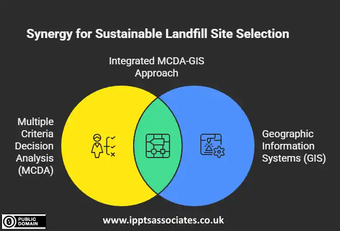
- Multiple Criteria Decision Analysis (MCDA) combined with Geographic Information Systems (GIS) provides the most comprehensive approach to sanitary landfill site selection, balancing environmental, social, and economic factors.
- Critical factors in landfill site selection include distance from water bodies, soil characteristics, proximity to residential areas, and topographical considerations to minimise environmental and public health risks.
- The Analytical Hierarchy Process (AHP) offers a structured methodology for weighing different criteria, making complex landfill siting decisions more objective and defensible.
- Proper landfill site selection can prevent groundwater contamination, reduce greenhouse gas emissions, and minimise community opposition.
- IPPTS Associates offers cutting-edge MCDA consultancy that helps municipalities and landfill site developers identify optimal landfill locations while ensuring regulatory compliance and community acceptance.
Introduction
Selecting the right location for a sanitary landfill is one of the most consequential decisions a municipality can make. It’s a choice that will impact environmental health, community well-being, and local economies for decades to come. While traditional approaches often prioritise single factors like cost or convenience, modern environmental planning demands a more sophisticated methodology.
Following principles of seeking a landfill site with the best environmental sustainability and social acceptability works well when using comprehensive MCDA tools designed to help communities make these critical decisions with confidence and precision.
The complexity of landfill site selection requires balancing multiple competing interests while addressing potential long-term consequences. Gone are the days when waste management facilities could be placed based on land availability alone. Today’s sustainable approach requires careful consideration of environmental protection, social equity, economic feasibility, and technical suitability—all evaluated systematically through Multiple Criteria Decision Analysis.

Finding the Perfect Landfill Site: Why Location Matters
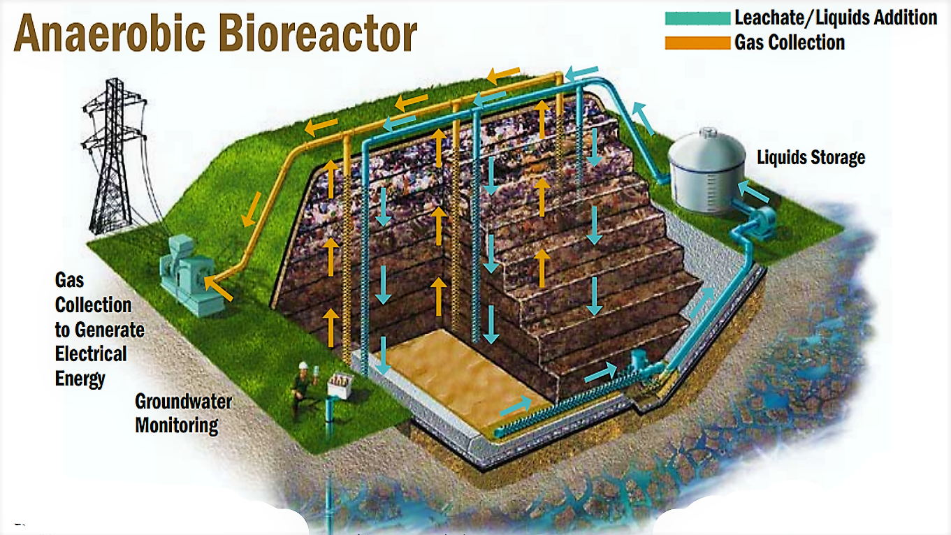
The consequences of poor landfill siting can be devastating and long-lasting. Leachate—the liquid that forms as waste decomposes—can contaminate groundwater and nearby water bodies, creating public health crises that may persist for generations.
Methane emissions contribute significantly to climate change, while odour and visual pollution can destroy property values and quality of life for surrounding communities. Getting location right isn’t just about environmental protection—it’s about protecting human health, economic stability, and social cohesion.
Sanitary Landfill Site Selection in the Past
Historically, landfills were often placed in the path of least resistance—areas with minimal economic value or politically marginalised communities. This approach has created lasting environmental justice issues, with disadvantaged populations bearing disproportionate burdens of waste management infrastructure. A scientific approach to site selection using MCDA helps ensure more equitable outcomes by objectively evaluating locations based on comprehensive criteria rather than political expediency.
Landfill Sites After Closure
Even well-designed landfills will eventually reach capacity, making proper initial siting crucial for long-term waste management planning. Sites must accommodate not just current needs but future expansion possibilities, integration with recycling and waste-to-energy facilities, and eventual closure and post-closure monitoring. The initial location decision sets the stage for decades of waste management practices and determines whether a community can achieve its sustainability goals.
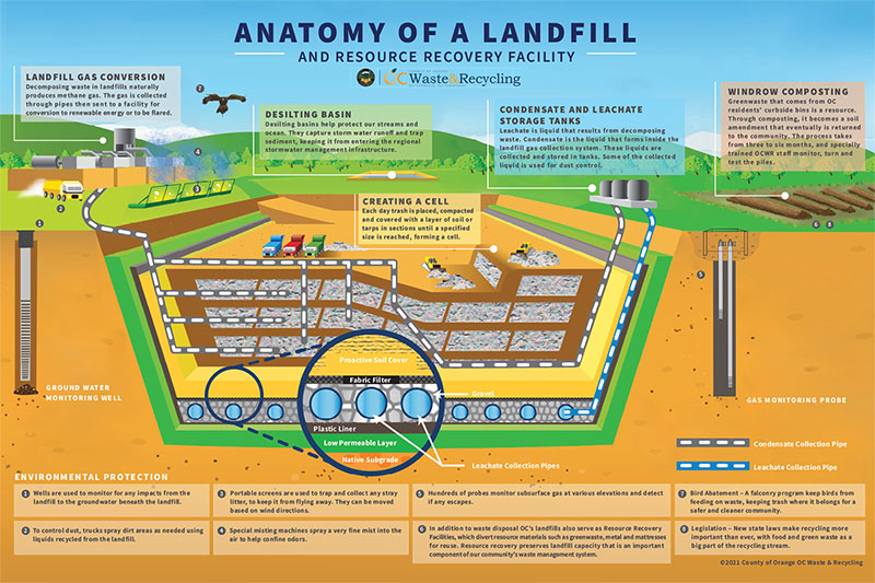
“Learn How Modern Landfills Work …” from www.dumpsters.com and used with no modifications.
Environmental Impacts of Poor Site Selection
When landfills are improperly sited, the environmental consequences extend far beyond the immediate area. Groundwater contamination can spread for miles, affecting drinking water supplies and aquatic ecosystems.
A single poorly placed landfill can render groundwater unusable for decades or even centuries.
Surface water impacts include eutrophication of lakes and streams from nitrogen-rich runoff, destroying fisheries and recreational opportunities. These hydrological impacts are particularly severe when landfills are placed in areas with high precipitation, permeable soils, or shallow groundwater tables. For more information on landfill siting, consider consulting landfill design consultancy services.
Air Quality Degradation
Air quality degradation represents another significant concern with improper landfill placement. Landfill gas—a mixture primarily of methane and carbon dioxide—contributes to the greenhouse effect and climate change when released untreated into the atmosphere.
When landfills are sited without considering prevailing wind patterns, odours and airborne contaminants can affect communities miles away from the actual facility.
Strategic site selection can mitigate these impacts by placing facilities where natural buffers and atmospheric conditions help contain potential air pollution. For more information on effective landfill site selection, consider exploring this GIS-based multicriteria evaluation technique.
Balancing Social, Economic, and Technical Factors
The social dimension of landfill siting cannot be overstated. Community opposition, often characterised as NIMBY (Not In My Back Yard) sentiment, can derail waste management planning and lead to costly delays or litigation.
Effective site selection must incorporate social acceptance factors, including distance from residential areas, visibility from roads and settlements, and cultural or historical significance of potential locations. The MCDA approach allows planners to quantify these seemingly subjective factors and include them in the overall site evaluation.
Economic Considerations
Economic considerations extend well beyond the initial land acquisition costs. Transportation distance from waste generation centres significantly impacts operational costs and carbon footprint over the facility’s lifetime. Site preparation expenses vary dramatically based on topography, existing infrastructure, and geological conditions.
Future liability and post-closure care costs must also be factored into the economic analysis. MCDA frameworks enable planners to conduct sophisticated cost-benefit analyses that consider these long-term economic implications rather than focusing solely on upfront expenses.
Technical Suitability
Technical suitability remains fundamental to successful landfill operation. Geology, hydrology, and climate conditions determine whether a site can physically accommodate waste disposal without environmental breaches.
Soil characteristics affect the facility’s ability to contain leachate, while topography influences surface water management and operational efficiency. Accessibility for waste transport vehicles and the availability of cover material must also be evaluated.
The best MCDA models incorporate these technical parameters alongside social and economic factors to identify truly optimal locations.
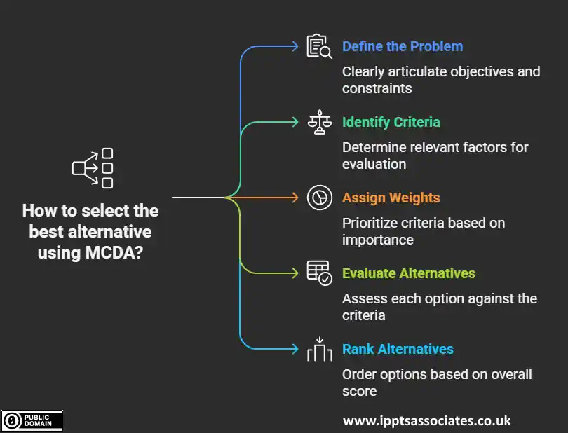
Multiple Criteria Decision Analysis: The Smart Approach to Landfill Siting
Multiple Criteria Decision Analysis represents a revolutionary advancement in environmental planning. Unlike traditional single-factor approaches, MCDA provides a structured framework for evaluating multiple, often conflicting criteria simultaneously. This methodology recognises that no perfect landfill site exists—every location involves tradeoffs among environmental protection, economic feasibility, social acceptance, and technical suitability.
By systematically analysing these tradeoffs, MCDA delivers more balanced, defensible, and sustainable siting decisions.
“Landfills | SSWM – Find tools for …” from sswm.info and used with no modifications.
What Makes MCDA Better Than Traditional Methods
Traditional landfill siting methods typically rely on elimination criteria, ruling out areas based on simple threshold values for a limited number of factors. While straightforward, this approach often fails to capture the nuanced reality of site selection. MCDA, by contrast, evaluates sites on a spectrum of suitability rather than binary acceptance or rejection. This approach recognises that minor deficiencies in one area might be offset by exceptional performance in others, allowing for more flexible and realistic site evaluation.
The mathematical rigour behind MCDA provides transparency and accountability that traditional methods lack. Each criterion receives a quantifiable weight based on its relative importance, and each potential site receives a score for each criterion. These scores are then aggregated using well-established mathematical formulas to produce overall site rankings. This systematic approach makes the decision-making process defensible against legal challenges and builds public trust through its objective methodology.
Perhaps most importantly, MCDA can incorporate stakeholder values directly into the decision-making process. By engaging community members, regulatory agencies, and technical experts in determining criteria weights, the process becomes more democratic and representative of diverse perspectives. This participatory approach often leads to greater public acceptance of the final site selection and helps prevent costly opposition later in the project development cycle.
Integrating Geographic Information Systems (GIS) with MCDA
The marriage of Geographic Information Systems with Multiple Criteria Decision Analysis has revolutionised landfill site selection. GIS technology enables planners to analyse spatial relationships between potential sites and important geographic features like water bodies, residential areas, and transportation networks. The layering capabilities of GIS allow for simultaneous visualisation of multiple criteria, creating powerful composite suitability maps that instantly communicate complex analysis results to decision-makers and stakeholders. For further insights into GIS applications, explore our leachate management and treatment consultancy services.
Data management capabilities represent another significant advantage of GIS-based MCDA. Modern landfill site selection typically involves processing enormous datasets—from topographical surveys and geological assessments to census information and land use records. GIS platforms efficiently organise these diverse data types, ensuring that all relevant information is incorporated into the analysis while maintaining data integrity throughout the process. This comprehensive approach prevents overlooking critical factors that might compromise the selected site’s long-term viability, such as environmental compliance.
The Role of Analytical Hierarchy Process (AHP)
Among the various MCDA methodologies, the Analytical Hierarchy Process stands out for its effectiveness in landfill site selection. Developed by mathematician Thomas Saaty, AHP provides a structured framework for organising complex decisions into hierarchies of criteria and sub-criteria. The process begins by establishing the decision objective (selecting the optimal landfill site), then identifying the main criteria categories (environmental, social, economic, and technical), and finally defining specific measurable factors within each category.
AHP’s pairwise comparison technique offers a particularly valuable tool for establishing criteria weights. Rather than arbitrarily assigning importance values, decision-makers compare criteria two at a time, determining the relative importance of each pair on a defined scale. These comparisons are assembled into matrices that generate mathematically sound weight values. This approach reduces the cognitive burden on decision-makers while producing more consistent and defensible weighting schemes than direct assignment methods.

“Analytic hierarchy process – Wikipedia” from en.wikipedia.org and used with no modifications.
Critical Factors That Make or Break a Landfill Site
Successful landfill site selection depends on identifying and properly weighting the factors most critical to both environmental protection and operational success. While specific criteria may vary depending on local conditions and regulatory requirements, certain factors consistently emerge as fundamental to responsible siting decisions. The following criteria represent the essential considerations that should be incorporated into any comprehensive landfill site selection process.
1. Distance from Water Bodies and Groundwater
Perhaps no factor is more critical to environmental protection than maintaining adequate separation between landfills and water resources. Regulatory standards typically establish minimum setback distances from lakes, rivers, streams, wetlands, and coastal waters, with distances ranging from 100 meters to several kilometres depending on the water body’s significance.
Even with modern liner systems, these buffer zones provide crucial secondary protection against potential contaminant migration. Areas with frequent flooding or high water tables generally receive automatic exclusion from consideration regardless of other favourable characteristics.
For more information on managing landfill-related issues, consider exploring leachate management and treatment consultancy.
2. Soil Characteristics and Geology
The underlying geology and soil composition significantly influence a site’s containment capabilities. Clay-rich soils with low permeability provide natural barriers against leachate migration, while sandy or gravelly soils allow rapid contaminant transport.
Beyond permeability, soil depth, bearing capacity, and erosion potential all affect construction feasibility and long-term stability. Geological considerations include distance from fault lines, presence of karst formations or sinkholes, and risk of seismic activity—all factors that could compromise containment structures.
3. Distance from Residential Areas
Creating adequate separation between landfills and human populations serves both social acceptance and public health objectives. Most regulatory frameworks specify minimum distances from residential areas, schools, hospitals, and other sensitive receptors.
These buffer zones help mitigate noise, odour, dust, and visual impacts while reducing exposure to potential airborne contaminants. Distance requirements typically range from 500 meters to 5 kilometres depending on facility size, local population density, and cultural factors. Sites meeting only minimum distance requirements generally receive lower suitability scores than those offering more substantial separation.
4. Accessibility and Transportation Networks
Efficient waste transportation directly impacts both economic viability and environmental footprint. Ideal sites offer access to major roadways capable of handling heavy truck traffic without requiring vehicles to pass through residential neighbourhoods or congested areas.
The distance from waste generation centres significantly affects transportation costs and associated emissions, with most authorities seeking to minimise haul distances while still maintaining adequate separation from population centres.
Sites requiring significant infrastructure development (road construction, bridge reinforcement) generally receive lower scores due to increased environmental disruption and economic costs.
5. Land Use and Land Cover
Existing land use patterns strongly influence site suitability from both practical and social perspectives. Agricultural lands, particularly those with prime or unique soils, typically receive protection against conversion to waste management uses.
Similarly, forested areas, recreational lands, and habitats supporting rare or endangered species generally warrant preservation.
Industrial brownfields or previously disturbed sites often represent ideal candidates for landfill development, offering productive reuse of already impacted land. Land ownership patterns also factor into this criterion, with publicly owned parcels often presenting fewer acquisition challenges than privately held lands.
6. Slope and Topography
Topographical features significantly impact construction feasibility, operational efficiency, and environmental protection. Ideal landfill sites feature gentle slopes (typically between 5% and 15%) that facilitate proper drainage without excessive erosion potential.
Extremely flat areas may present drainage challenges, while steep slopes increase construction costs and stability concerns. Natural topographical features that provide visual screening (hills, ridges) can enhance a site’s suitability by reducing aesthetic impacts on surrounding areas.
Sites requiring extensive earthwork modification generally receive lower suitability ratings due to increased environmental disruption and construction costs.
7. Environmental and Regulatory Constraints
Beyond basic environmental factors, numerous regulatory designations can affect site suitability. Protected areas like national parks, wildlife refuges, and conservation easements typically receive automatic exclusion from consideration.
Historical and archaeological sites warrant similar protection to preserve cultural heritage. Designated wetlands, critical habitats, and ecologically sensitive areas generally receive either exclusion or significant suitability penalties depending on regulatory frameworks.
These constraints often appear as “red flag” indicators in preliminary screening, immediately eliminating sites regardless of performance on other criteria.
8. Groundwater Depth
The vertical separation between a landfill’s base and the underlying groundwater represents a critical environmental protection factor. Regulatory standards typically require minimum separation distances ranging from 1.5 to 10 meters, depending on local hydrogeology and liner system specifications.
Greater separation distances provide enhanced protection by allowing natural soil filtration and attenuation of any contaminants that might escape engineered containment systems. Areas with fluctuating groundwater tables require careful seasonal monitoring to ensure compliance with minimum separation requirements throughout the year.
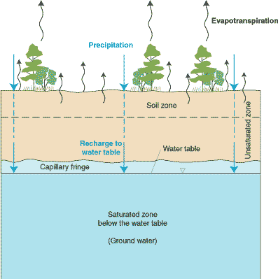
“Facts and Concepts about Ground Water” from pubs.usgs.gov and used with no modifications.
Case Studies from Urban Environments
The metropolitan area of Portland, Oregon provides a compelling example of successful MCDA application in urban landfill siting. Facing rapid population growth and diminishing capacity in existing facilities, authorities employed a comprehensive GIS-based MCDA process incorporating 17 distinct criteria. What distinguished this project was its innovative weighting scheme, which gave environmental justice indicators equal importance to hydrogeological factors. The selected site not only met all technical requirements but also achieved unprecedented community acceptance through its careful consideration of socioeconomic impacts and transportation equity.
Rural Application Challenges and Solutions
Rural areas face unique challenges in landfill site selection, often stemming from limited data availability and specialised environmental concerns. In Montana’s Bitterroot Valley, planners overcame sparse population density data by incorporating mailbox clustering analysis to more accurately reflect actual residential patterns. The traditional buffer-zone approach would have missed several small unincorporated communities that the enhanced analysis identified and protected.
Another rural-specific challenge involves agricultural protection. When Nebraska’s Platte River Valley authorities needed a new regional landfill, they modified standard MCDA methodologies to give exceptional weight to prime farmland preservation.
This modification led to selecting a former gravel extraction site that offered excellent geological characteristics while preserving valuable agricultural lands. The case demonstrates how MCDA frameworks can be customised to address region-specific priorities without compromising technical integrity.
Common Pitfalls to Avoid in Landfill Site Selection
Even with sophisticated MCDA tools, landfill site selection processes can go awry when certain common pitfalls aren’t actively avoided. These mistakes often arise not from technical limitations but from procedural oversights or institutional biases.
Recognising these potential stumbling blocks in advance can save communities significant time, resources, and conflict while ensuring more sustainable outcomes. The most successful projects address these challenges proactively rather than reactively.
Overlooking Community Concerns
Perhaps the most costly mistake in landfill site selection is failing to meaningfully integrate community perspectives from the earliest planning stages. When technical experts define criteria and weights without public input, they risk creating mathematically perfect solutions that face insurmountable public opposition.
Effective processes engage diverse stakeholders in defining what matters most in site selection before any technical analysis begins. This early engagement helps identify social and cultural factors that might not appear in standard environmental or engineering assessments, such as unofficial recreational uses, community gathering spaces, or culturally significant landscapes.
For more insights, consider exploring landfill site selection using GIS-based techniques.
Inadequate Data Collection
- Relying on outdated or low-resolution topographical data that misses important terrain features
- Using regional groundwater maps without site-specific verification of water table depths
- Failing to conduct proper soil borings to verify subsurface conditions
- Neglecting to gather multi-seasonal ecological data that might reveal temporary wetlands or wildlife usage patterns
- Omitting traffic pattern analysis during peak hours or seasonal variations
The quality of MCDA outputs depends entirely on the quality of inputs. Many site selection processes falter because they rely on convenient but inadequate data sources. High-quality decision-making requires investing in comprehensive, current, and appropriately scaled data across all relevant criteria.
When budget constraints limit data collection, sensitivity analysis becomes especially important to understand how data uncertainties might affect final recommendations. For more insights on effective site selection, consider exploring landfill design consultancy services.
Landfill Site Selection Using Multiple Criteria Decision Analysis (MCDA/MADD) Template, Plus Consultancy Service Appointment Checklist: Only $17
Avoid Criterion Slippage
One particularly problematic pattern involves “criterion slippage,” where practitioners substitute easily measured proxy variables for what they actually want to assess. For example, using simple distance to residential areas instead of properly modelling noise propagation patterns, or using land cost as a proxy for development suitability. These substitutions can lead to systematic biases in site selection, often favouring certain types of locations regardless of their actual merits.
Another data-related pitfall involves inappropriate scale matching. When combining data layers with different resolutions or collection methodologies, inconsistencies can create misleading composite results.
For instance, highly detailed soil data might be combined with generalised groundwater information, creating artificial precision in some areas while masking important variations in others. Successful MCDA processes harmonise data scales appropriately while acknowledging limitations in the final analysis.
Failing to Consider Long-Term Factors
Landfills represent multi-generational commitments to a particular land use, yet many site selection processes focus predominantly on current conditions without adequately considering future changes. Climate change projections rarely factor into hydrological assessments despite their significant implications for precipitation patterns, flooding potential, and groundwater dynamics.
Similarly, demographic projections often receive insufficient attention, potentially placing facilities in the path of future development. Effective site selection must incorporate long-term climate models, regional growth plans, and infrastructure development projections to ensure selected sites remain suitable throughout their operational life and post-closure monitoring period.
Making the Final Decision: Beyond the Technical Analysis
While MCDA provides powerful analytical capabilities, the final landfill siting decision ultimately requires human judgment that balances quantitative results with qualitative considerations. The highest-scoring site mathematically may not always represent the optimal choice when all factors are considered holistically.
Decision-makers must recognise that MCDA serves as a decision support tool rather than a decision replacement mechanism, providing structure and transparency to the process while still requiring thoughtful application of human experience and values. For more insights on landfill management, explore our landfill design consultancy services.
Scenario Testing
One approach for bridging technical analysis and final decision-making involves scenario testing with different weighting schemes. By examining how site rankings change when different stakeholder perspectives are emphasised, decision-makers gain insight into the robustness of potential solutions. Sites that perform well across multiple scenarios generally represent more resilient choices than those that excel under only specific weighting approaches.
Ultimately, successful landfill siting requires both technical excellence and procedural legitimacy. Even perfect technical analysis will fail if the process lacks transparency, inclusivity, and perceived fairness. The most successful projects maintain a clear distinction between technical evaluation (where MCDA excels) and value judgments (where stakeholder engagement becomes essential), while ensuring both components receive appropriate attention and resources.
Incorporating Public Participation
Meaningful public participation goes beyond simple information sharing or consultation to actually influence the decision-making process. Effective approaches engage community members in defining evaluation criteria, establishing criteria weights, and reviewing preliminary results before final recommendations are formed. This participatory approach not only improves the substantive quality of decisions by incorporating local knowledge but also enhances procedural legitimacy by giving stakeholders genuine influence over outcomes.
The timing of public engagement significantly impacts its effectiveness. Many failed siting processes delay community involvement until after technical experts have already narrowed options to a short list of sites. This approach inevitably creates defensive reactions from affected communities who reasonably feel excluded from meaningful participation. Best practices involve early engagement when fundamental questions about evaluation approach and community priorities remain open for genuine influence.
Regulatory Compliance Considerations
Beyond technical and social factors, regulatory requirements establish non-negotiable constraints on landfill siting. These requirements vary by jurisdiction but typically include minimum separation distances from water bodies, airports, fault lines, and sensitive habitats, along with specific design standards based on local environmental conditions.
Successful siting processes incorporate these regulatory requirements as threshold criteria while using MCDA to optimise among legally compliant alternatives. This approach ensures that final recommendations satisfy both minimum legal standards and broader community objectives for environmental protection, economic efficiency, and social acceptance.
Frequently Asked Questions
As communities increasingly adopt MCDA approaches for landfill site selection, certain questions consistently arise from stakeholders, officials, and technical practitioners. The following responses address the most common inquiries about this methodology, providing practical guidance for those considering or implementing MCDA-based site selection processes.
“Multiple Criteria Decision Analysis represents the gold standard for landfill site selection. When properly implemented, it transforms a politically contentious process into a transparent, defensible methodology that balances environmental protection with practical operational needs.”
— Dr. Elena Sanchez, Environmental Engineering Journal
The transition to MCDA-based approaches represents a significant advancement in environmental planning, moving from subjective, often politically driven decisions toward evidence-based processes that can withstand technical and legal scrutiny. While implementing these methods requires greater initial investment in data collection and analysis, the long-term benefits in terms of environmental protection, operational efficiency, and community acceptance far outweigh these upfront costs.
For communities beginning this process, consulting with experienced practitioners and reviewing successful case studies can provide valuable guidance on adapting MCDA frameworks to local conditions and priorities. The following questions address specific practical concerns that frequently arise during implementation.
1. How long does a typical landfill site selection process take using MCDA?
A comprehensive MCDA-based landfill site selection process typically requires 12-18 months from initial planning to final recommendation. This timeline includes approximately 2-3 months for defining objectives and criteria, 4-6 months for data collection and processing, 2-3 months for analysis and preliminary rankings, and 3-4 months for stakeholder review, sensitivity testing, and final decision-making.
Rushed processes that attempt to compress these timeframes often suffer from data inadequacies or insufficient stakeholder engagement, creating vulnerabilities to legal challenges or community opposition.
Several factors can extend this timeline, including seasonal data collection requirements (such as wildlife surveys that must cover breeding seasons), complex hydrogeological conditions requiring extended monitoring, or particularly contentious community contexts necessitating additional engagement rounds.
Conversely, areas with excellent existing data infrastructure and proactive planning departments may complete the process more efficiently without compromising quality.
2. What’s the difference between MCDA and traditional landfill siting methods?
Traditional landfill siting typically employs a sequential elimination approach, applying minimum threshold requirements to progressively narrow potential locations until reaching a manageable number of candidate sites. This method tends to emphasise easily measured technical factors while treating social and environmental concerns as secondary considerations or simple yes/no constraints. The process often lacks transparency in how various factors are balanced against each other, making decisions vulnerable to criticism and challenge.
MCDA, by contrast, evaluates sites holistically across multiple dimensions simultaneously, recognising that excellence in some areas may compensate for limitations in others. This approach explicitly quantifies the relative importance of different factors through structured weighting processes, creating transparent accountability for how competing values are balanced.
MCDA also excels at integrating qualitative social factors alongside quantitative technical measurements, providing a more comprehensive evaluation framework that better reflects the full spectrum of community concerns.
3. Can MCDA help reduce community opposition to new landfill sites?
When properly implemented with genuine stakeholder involvement throughout the process, MCDA can significantly reduce the intensity and effectiveness of opposition to new landfill sites. The methodology’s transparency allows concerned citizens to understand exactly how sites were evaluated and why particular locations were selected, addressing the suspicion of political favouritism that often fuels opposition.
More importantly, when community members participate in establishing evaluation criteria and weights, the resulting recommendations reflect broader values beyond narrow technical considerations, creating outcomes with greater perceived legitimacy even among those who might prefer different locations.
4. How expensive is it to implement a GIS-based MCDA approach?
Implementation costs for GIS-based MCDA typically range from $150,000 to $500,000, depending on project scope, existing data availability, and regulatory complexity. This investment includes specialised software licensing, technical consulting services, data acquisition, field verification studies, and public engagement processes.
While this represents a significant expenditure, it typically constitutes less than 1% of the total lifecycle cost of a modern landfill facility, making it a prudent investment to ensure optimal siting decisions that will affect operations for decades.
Many jurisdictions successfully reduce these costs by leveraging existing GIS infrastructure, partnering with academic institutions for technical support, or coordinating data collection with other planning initiatives.
The most significant cost driver typically involves acquiring or developing high-resolution environmental data for specific criteria where existing sources prove inadequate. Sensitivity analysis can help identify which data gaps most significantly affect outcomes, allowing for targeted investment in the most critical information needs.
5. What software tools are available for landfill site selection using MCDA?
Several software platforms support MCDA-based landfill site selection, ranging from specialised waste management applications to more flexible general-purpose decision support systems. The optimal choice depends on existing technical capacity, budget constraints, and specific analytical requirements for the project at hand.
- ArcGIS with Spatial Analyst Extension – Provides comprehensive GIS capabilities with robust MCDA functionality through weighted overlay tools
- IDRISI/TerrSet – Offers specialised MCDA modules specifically designed for environmental applications
- DEFINITE – Dedicated MCDA software with strong visualisation capabilities for communicating results to non-technical audiences
- QGIS with MCDA plugins – Open-source alternative providing cost-effective implementation options
- Custom R or Python implementations – Offers maximum flexibility for unique analytical requirements when standard tools prove insufficient
Training in GIS Techniques and MCDA Methodologies
Beyond software selection, successful implementation depends on having personnel with appropriate training in both GIS techniques and MCDA methodologies. Many jurisdictions find that forming interdisciplinary teams combining environmental engineers, GIS specialists, and public engagement professionals yields the most effective results. These diverse skill sets ensure that technical analysis remains grounded in practical operational requirements while effectively communicating with diverse stakeholders.
For smaller communities with limited technical resources, regional partnerships often provide the most cost-effective approach to implementing sophisticated MCDA processes. By sharing expertise and costs across multiple jurisdictions, these collaborative efforts can achieve analytical rigour that might be unattainable for individual small communities working alone. For example, engaging with landfill design consultancy services can offer valuable insights and technical support.
Integration of Artificial Intelligence
The integration of artificial intelligence and machine learning capabilities represents the next frontier in landfill site selection technology. These advanced tools can identify non-obvious patterns in environmental data and optimise selection criteria weightings based on outcomes from previously successful projects. While still emerging, these approaches show particular promise for addressing complex, data-rich siting challenges in densely populated regions where competing land uses create especially difficult tradeoffs.
As waste management practices continue evolving toward circular economy models, future MCDA applications will likely incorporate more sophisticated life-cycle analysis components that consider not just immediate siting impacts but also long-term resource recovery potential. This evolution reflects the growing recognition that today’s waste facilities must be designed not simply for disposal but as integrated components of sustainable materials management systems.
IPPTS Associates offers cutting-edge MCDA implementation services that combine technical excellence with community-centred approaches. Our team provides the expertise needed to navigate complex siting decisions while building stakeholder trust and regulatory compliance.


You must be logged in to post a comment.